To this day, my family is living in the same house they had built in 1964 in Vila Madalena, São Paulo. When they moved in, the streets were unpaved and the homes weren’t hidden behind gates, both conditions that are unimaginable to me now. When I think of the future generations of my family, I imagine a similar scenario where they do not believe me when I explain how the neighborhood once wasn’t a sea of luxury condominiums.
As I grew older, I noticed the neighborhood changing. Old stores were closing, new businesses were popping up, and homes were demolished to erect tall condominiums. Out of nowhere, developers were desperately trying to purchase our home. My neighborhood had never been so valorized to the extent that my own family would not be able to afford a studio apartment in the area. Therefore, for my capstone, I wanted to understand what was happening to my neighborhood.
When I started investigating the transformations of Vila Madalena, I learned that the community was zoned as a “Structuring Axes of Urban Transformation (EETU in Portuguese)” in São Paulo’s 2014 Master Plan because of its proximity to the Vila Madalena Metro station. EETUs were created to address the city’s urban sprawl legacy, high car ownership, and traffic congestions by encouraging public transportation use through densifying and verticalizing the transit areas. Only EETU designated areas are permitted to construct new high-rise buildings with a floor area ratio (FAR) of 4 or higher. The rest of the municipal region has a default FAR of 1 and developers must purchase the right to build above it. This incentive, along with the proximity to the metro station and the Bohemian character of Vila Madalena, has attracted the attention of developers as a profitable investment and triggered an urban transformation.
As someone who had the privileged to learn about urban phenomenons at an academic institution in the United States, I recognize that a concept such as gentrification might not be known by many. When I ask my family and people in my neighborhood if they knew what gentrification meant, majority said no. But after I explained what it is, everyone understood immediately and said that it is exactly what the neighborhood is going through.
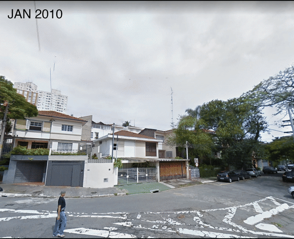
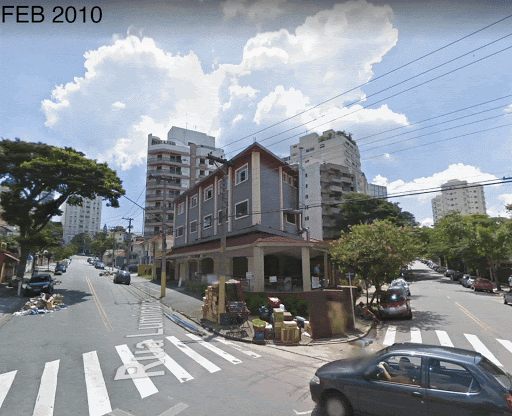
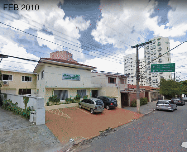
Therefore, this showed to me that people know what gentrification is, they just don't know the name. This inspired me to think of other ways of representing and explaining gentrification without using academic jargon as academia has a legacy of exclusion and gatekeeping. Therefore, this lead me to present gentrification through motiongraphics. To show the neighborhood’s changing landscape, I examined the neighborhood through Google Street View, dating back to 2010. I identified 32 new developments in the research site and captured screenshots of them throughout the years to create time-lapse videos.
My research demonstrated rather clearly that the neighborhood’s transformation can be defined as Transit-Induced Gentrification. The proximity to the metro station and the city’s policies aimed at promoting density, vertical expansion, and public transportation usage ultimately only facilitated the construction of luxury condominiums with underground private garages. This resulted in an explosion of housing prices that very few can afford. My home is a five-minute walk from the metro station, which has always been a privilege for me, but real estate developers have turned it into a burden.